Whenever people come to NYC they ask me where to go riding. My default answer is: go ride 9W. All other routes require a bit of faff (cycling to Brooklyn requires getting over bridges and invariably some highly trafficked roads, cycling north-east out of the city requires a number of trafficked roads and turns. 9W is probably most people’s default answer as it is always busy when the sun is shining.
Here’s a few pointers.
Getting out of NYC
The only option for getting to this route is cycling up to George Washington Bridge and crossing. (Technically I guess you could get the NY Waterway boat across the river but you’d have to cycle on River Road northwards which isn’t very bike-friendly. I’ve been knocked off my bike there and I know of at least 3 other skilled riders being taken down on that road. Avoid!). So how do I get to the bridge? More specifically, how do I get to the South Walkway on the bridge? There is a north side walkway but it requires getting off your bike and carrying your bike up and down some stairs (not that many, but still). You can click the maps to go directly to Google Maps.
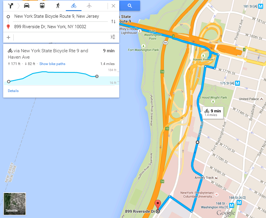
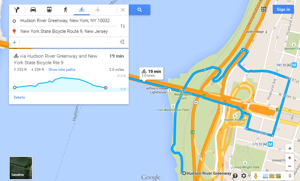
- Ride North on the West Side Highway from anywhere in the city. Keep riding until you go under the bridge itself. This is mostly flat but when you get to the bridge you have to head up a steep incline which levels off after ~50m only to go even steeper again (20% incline +) for another 50m. If you hate hills or not comfortable riding in traffic, I would still recommend this way because you can walk up that hill pretty quickly. Once you get up the hill continue north and cross the bridge that goes over the highway. Turn right as you come off the bridge and then take the first left. You’ve then got to climb a little and then turn right at the second set of traffic lights onto Fort Washington Avenue. From there you should see signs on how to cross the bridge, but if you don’t see them, go south crossing the traffic lights where cars enter the bridge. Continue to 177th street and turn right, then right after two blocks. You’ll see the ramp for bikes.
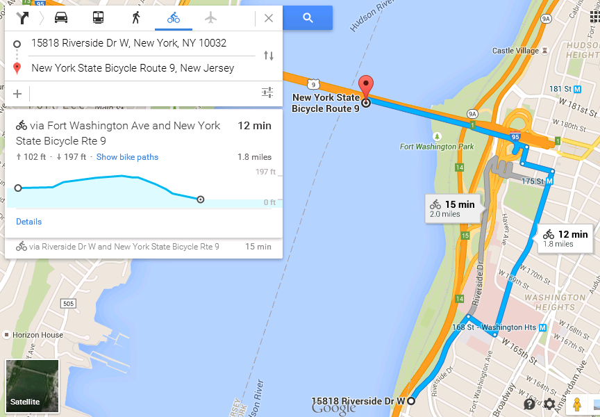
- The other option is to ride on Riverside Drive. This is the route I normally take because it’s closed to commercial traffic so isn’t highly trafficked and additionally you don’t have to navigate joggers and other bikes on the west side highway (WSH). The more ‘serious’ bikers tend to take this route. Get onto Riverside drive (see below for details) and head north. Keep going north. Turn right on 165th street and head up a short climb and turn left at the traffic lights. You’ll know you’re on the correct path if you pass the hospital on your left. Turn left on 177th street and take the second right where you’ll see the bike ramp.
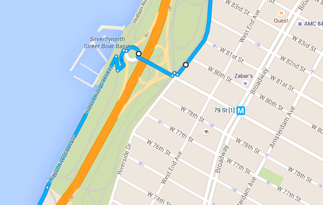
- Getting onto Riverside drive from the Westside highway. My preferred method is to get on at 79th street. You cycle north on the westside highway. When you get into the 50s the path diverges from the main road, you cycle underneath the highway for a little bit. Once you’ve passed this section you’ll be cycling directly next to the river, this is where you need to be alert to exit. You’ll pass a few toilets and then you’ll get to the Boat Basin bar which will be on your right. Do a little U turn onto the path and cycle up, then take your first left which is again uphill. You’ll enter a traffic cycle/roundabout/roundpoint (whatever you want to call it), be careful here as there is traffic. Take the second exit (NOT THE FIRST as it’ll take you onto the highway). You’ll get to some traffic lights where you turn left onto Riverside Drive.
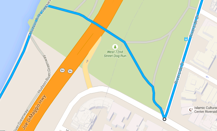
- An alternative with less traffic but more pedestrians and dogs is to get onto Riverside Drive at 72nd. In this case, you cycle north on the WSH and when you leave the bike path with the highway above it, you take your first right up the path. You’ll be confronted with some stairs which you can walk up, or take the ramp just to the left of it. You’ll then go through the little tunnel and take the right fork with the dog park on the right. When you meet the road, take the left onto Riverside Drive. There are other options to get onto Riverside Drive from the highway but these two are pretty simple and generally doesn’t involve invoking the wrath of pedestrians.
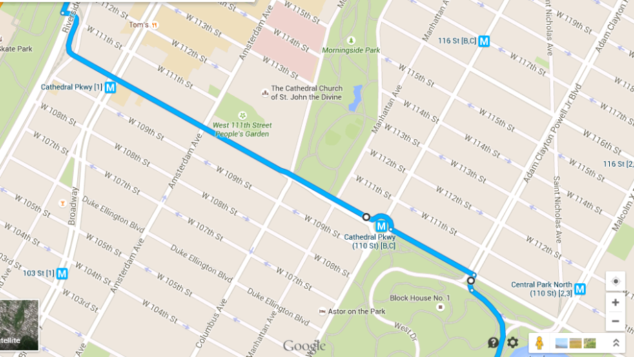
- Let’s say you get to Central Park and there is a race on, it’s busy, or you just want to go further, You can exit the park pretty anywhere at or above 72nd street and just head west until you hit Riverside. The easiest way is just to exit the North side of the park and then head west on 110th street. If you’re really scared of traffic you can go west on 106th Street (it’s actually called Duke Ellington Boulevard) where there is a cycle path in both directions.
- Getting onto Riverside drive from the Westside highway. My preferred method is to get on at 79th street. You cycle north on the westside highway. When you get into the 50s the path diverges from the main road, you cycle underneath the highway for a little bit. Once you’ve passed this section you’ll be cycling directly next to the river, this is where you need to be alert to exit. You’ll pass a few toilets and then you’ll get to the Boat Basin bar which will be on your right. Do a little U turn onto the path and cycle up, then take your first left which is again uphill. You’ll enter a traffic cycle/roundabout/roundpoint (whatever you want to call it), be careful here as there is traffic. Take the second exit (NOT THE FIRST as it’ll take you onto the highway). You’ll get to some traffic lights where you turn left onto Riverside Drive.
Wow, that was longer than expected. Now let’s assume you took one of those routes and got onto the bridge. Keep in mind these things:
- Winds can get strong on the bridge where it’s very exposed. Be careful passing cyclists and pedestrians.
- There are sometimes tourists hidden behind the support beams that like to step out and play Russian Roulette with cyclists (forgetting it it an active cycle path).
- It’s two way traffic, stay to your right. If you pass, pass only on the left and announce yourself “On your left” in your most friendly polite tone possible!
- There are a couple sections on the bridge where you take blind turns. Use the mirrors to see around the corner or just go slow.
- If it’s icey out, the metal beams on some sections are extremely slippery! I went down once. Okay, maybe twice.
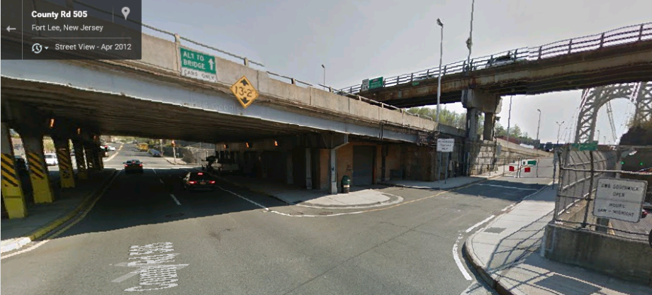
Hopefully you made it to New Jersey. Congratulations. Give yourself a little high five for not getting lost, hitting anyone, getting a ticket from policeman, etc. The west side of the bridge is the perfect place for meeting people as there is square concrete section where there is no traffic:
 Now you can go via the parkway (hillier) or via the main road (less hilly).
- During winter the park is closed. Often the gates will be closed but cyclists will go round the gates anyway. I’ve not heard of anyone being ticketed for this, so I guess the gates are closed for car traffic, and not cyclists. I’m not sure though, you can call the Park Commission if you want to check.
To get here take the left when you exit the bridge staying on the path (not the road). You’ll go down a 1/4 mile hill that can get pretty quick (stay to the right in case cyclists come up hill on the same path). Turn left into the park. Keep cycling north on the park until you pass the ranger station and then follow the road to the left where you’ll hit a T junction. The road that runs left to right is 9W. Left takes you back to the bridge. Right takes you on for miles more riding.
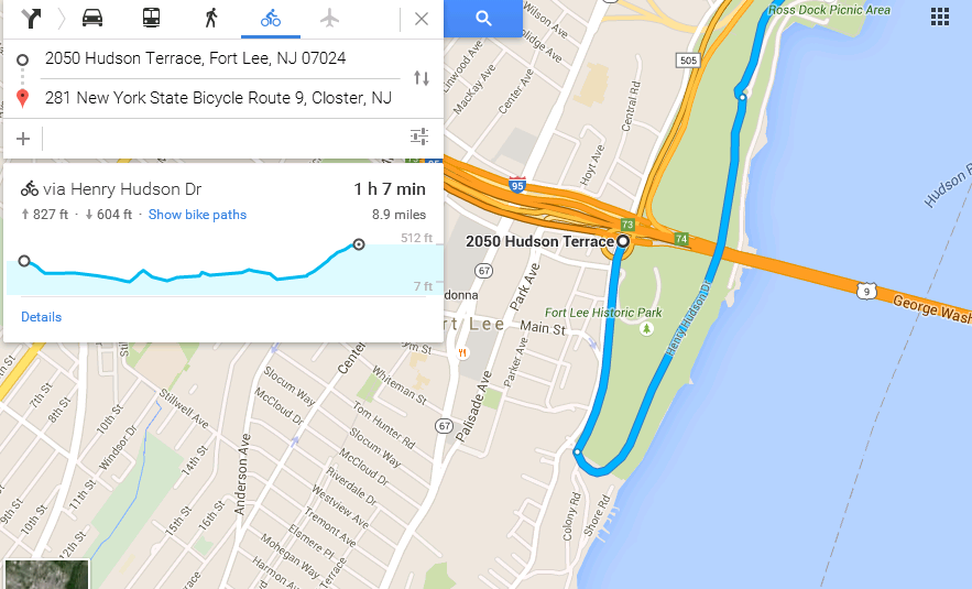
- Alternatively you can stick to the road. In this case turn right out of the bridge and get onto the road. You’ll cycle past Strictly Bicycles (on the left) which is a great place to get food supplies, a cheeky coffee and maybe a new high-end bike if your wallet is feeling heavy. Stick with this road until you get to the end which is a T junction. Turn left, then take the right at the traffic lights. This is 9W. Happy riding.
Some notes on 9W
- There isn’t much on the road so bring flat kit, water, etc. There are many cyclists which is good, but also bad because most cyclists will assume that someone else will stop for you. If you’re in trouble then call out to someone and they’ll be happy to help you… hopefully.
- Bike shops on the route are: Strictly Bicycles near the start. And Toga, well into the journey. And, Nyack Bicycle Outfitters (I’ve not actually been in strangely).
- Recommended Food Stops: Filling station (my favourite – they have real food as well as baked goods), Bunbury for coffee and pastries in Piermont, and Runcibles in Nyack.
- Most people don’t go out beyond Nyack so if you go further there are fewer cycle-heavy cafes.
- You can go all the way to Bear Mountain (and beyond) with few traffic lights.
- Keep a lookout for the green ‘Route 9’ bicycle route signs. There are turns along the way so if you don’t have a map, and refuse to keep an eye out for them, you will probably go the wrong way somewhere.
- Here’s a site with some cue sheets from George Washington Bridge (GWB) to Nyack.
- A mapmyride route from Central Park all the way to Bear Mountain and back (~100 miles). The outbound journey takes you to Bear Mountian via 9W, and the return is an alternative route back.
One last note. To get back onto Riverside drive from the GWB is slightly different:
- Go back down the cycle ramp you went up. At the exit of the ramp turn right (going up the walkway/pavement). Turn right back onto the road (which has cycle lanes in both directions. Turn right to get back onto 177th street. Take the first left onto Haven Avenue (if you don’t turn left you’ll enter the highway!). At the end of Haven Avenue turn right onto Fort Washington Avenue. Then you’ll pass the hospital again and turn right onto 165th street and go down the hill. Turn left on Riverside drive to go downtown again.